

On the evening of Thursday, September 11, the skies opened up and unleashed a heavy downpour over a narrow band of southeastern Manitoba, prompting flash floods. Overnight Niverville saw 99 millimetres of precipitation. Just to the southeast, Steinbach received about 142 millimetres.
The slow-moving system was characterized by a thin band of storm clouds that repeatedly formed over the same area.
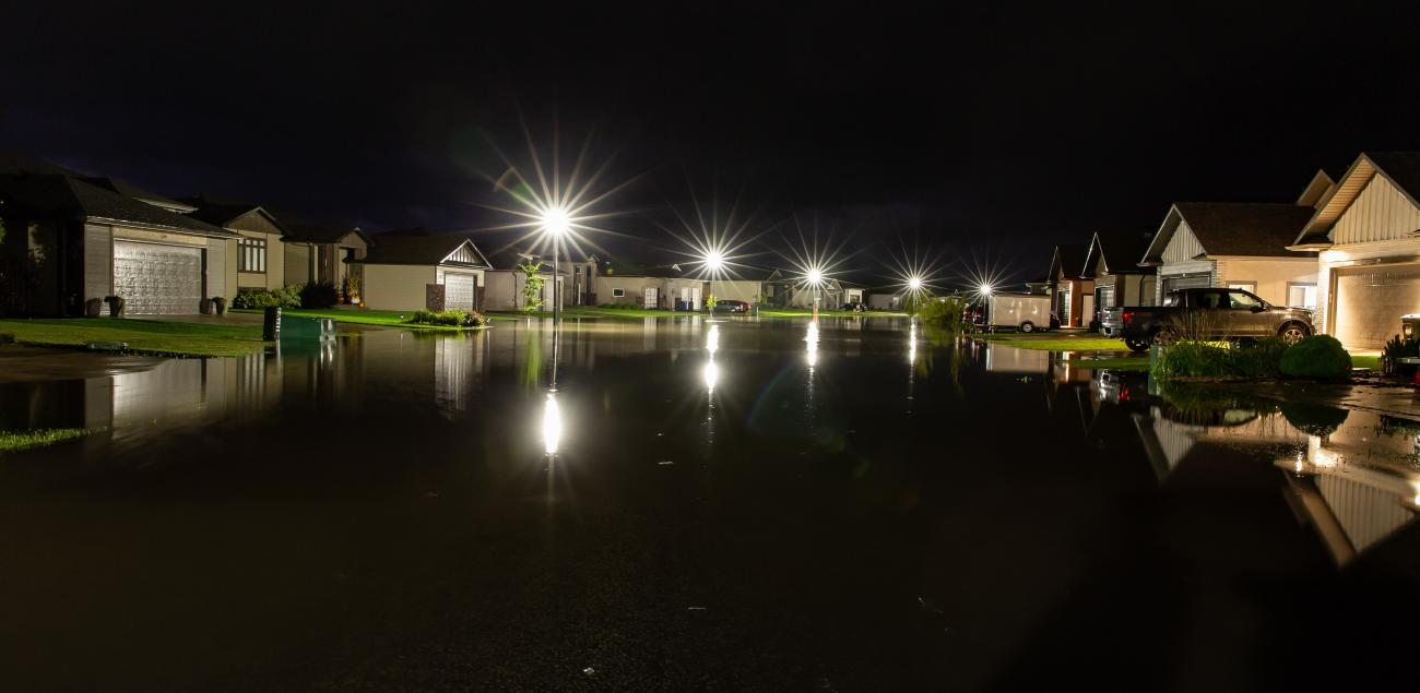
Anton Shvets, a photographer from Niverville, was drawn to the active sky that evening.
“At first, it was breathtaking: an unusual natural event with lightning flashing nonstop for almost an hour and thunder rolling endlessly,” Shvets says. “But then the heavy rainfall became concerning.”
By the time the downpour ended around midnight, he headed outside and captured images of the aftermath: St. Andrews Way, a residential street at the southwest side of town, was underwater.
“The water reached people’s garages and driveways, and some small cars could not pass,” he says. “They had to turn back, unable to reach their homes… When we returned home, my son showed me online posts where many people said their basements were starting to flood. One woman wrote that her basement was filling with water and that she needed help. My son and I went over to assist her, moving her belongings and vacuuming out water with a wet vacuum.”
That neighbour was Bobbi Jo Castaneda, who received an alert at 11:45 p.m. from the water sensor in one of her window wells.
“Within 15 minutes of the first alert, water was pouring in both of our window wells, and our sump pump was overflowing,” says Castaneda. “I had eight people show up at my door at midnight after I put out an SOS call on our community Facebook page. It was incredibly heartwarming. The help has not stopped since. We are tremendously blessed.”
Despite best efforts, both preventative and reactive, Castaneda’s insurance isn’t likely to fully compensate her family for all the damage their home sustained.
Still, she recommends homeowners install water sensors in their basement windows, a first step that can prevent a lot of later damage. She says they also have sensors under every sink, as well as between laundry machines, and in the sump pump area.
Science of Storm Formation
Dr. John Hanesiak, professor of atmospheric science at the University of Manitoba, is collaborating with Canadian Severe Storms Laboratory at Western University in London, Ontario. The lab, according to its website, is “the authoritative source for Canadian severe convective storms data and research.” Its researchers conduct storm damage surveys across Canada for events such as tornadoes and hail, and they’ve recently expanded their scope to include flash flood events.1
The recent storm that swept through southeastern Manitoba is the first flash flood event the lab is investigating in our province.
“This particular storm is what we call an elevated thunderstorm,” says Hanesiak. “Most storms we typically see in the middle of the afternoon are surface-based and feed off airflow that is close to the ground. These ones are different. They were feeding off air that was quite high off the ground.”
In the lead-up to the storm, he says, there was a warm front moving through North Dakota.
“In this type of scenario, airflow moving across that front flows up into it and lifts the air as it moves north,” he says. “That lifting can lead to storm development, like what we saw. It is sort of a common thing that southern Manitoba can get in the summertime, so it is a little unusual to see this activity particularly in the middle of September.”
Continuous thunder and lightning is another indicator of an elevated storm.
“With elevated storms, there is a lot of intercloud lightning. Most of this lightning won’t strike the ground, because most of the electric field is contained in the lower to upper atmosphere and doesn’t necessarily make electrical connections to the ground. It can, of course, but most activity will be within the cloud itself.”
One question many people are quick to wonder about is whether this sort of extreme weather event can be linked to climate change.
Hanesiak points out that it’s difficult to attribute individual events to large trends. However, he adds that these types of events do seem to be occurring at a higher frequency.
“As the atmosphere and planet warms, it can hold more water vapour,” he says. “The event that occurred in southern Manitoba is happening more frequently and more intensely worldwide… Rather than relative humidity, we use dew point temperature [to predict precipitation], which is the temperature at which air needs to reach to become saturated. The dew points have been in the upper teens, which is unusual for this time of year.”
He adds that this storm is largely due to a phenomenon called convection.
“Akin to an air balloon, once the air becomes buoyant, it gets released and the storms form. When you lift air in the atmosphere, it cools and condenses, and that’s what creates the cloud and the rain. The more vigorous that convection is, generally you get higher precipitation.”
One of the key characteristics of this event was the broader weather pattern behind it. As a slow-moving upper trough, a low-pressure system, moved over the Rockies, it allowed warm, humid air from the southern U.S. to stream into southern Manitoba. That lingering system created unusually humid conditions for mid-September and set the stage for fast-forming storms and flash flooding.
Drainage Issues
After the storm, due to the natural drainage of this region, all the rainfall that hit Steinbach and its surrounding communities ultimately flowed towards Niverville on its way into the Red River, producing a strain on town infrastructure.
In response to some resident concerns, Niverville Mayor Myron Dyck took the opportunity to outline the town’s flood prevention and diversion efforts, much of which was instituted following the flood of 1997.
“After the flood of 1997, the province installed a dike system around the town to reduce how much water flows through the community,” Dyck says. “Along with a series of sluice gates and berms, that infrastructure now helps redirect water around town. Water enters by Crown Valley Road on our southeast corner of town and exits out of the northwest toward the Red River.”
Indeed, some residents noted water backing up around Crown Valley Road, which sits at a higher elevation relative to neighbouring streets.
“If water is backing up on Crown Valley Road, it could be that the sluice gates allowing water into town are closed and thereby diverting water in and around the ditching that is around the community,” Dyck says.
He notes that water flow can also become impeded as it exits the northwest side of town.
“We’ve been in conversation with our neighbours in the RM of Ritchot, as well as the province, about keeping that drain clear of things like cattails, sludge, and other debris. When the drain isn’t flowing properly, water can back up.”
Geography also plays a role. Niverville is essentially flat with fewer than 12 inches of elevation from one end of town to the other, a grade of less than one percent.
“From one year to another, a frost heave is enough to offset a culvert that should’ve been draining but is now too high or too low,” Dyck said.
The goods news is that only a limited number of homes in Niverville were impacted by flooding in this recent storm. Still, Dyck says the event serves as a reminder about the importance of flood preparedness. He encourages residents to take preventative steps, from checking yard grading to maintaining or backing up sump pumps.
REFERENCE
1 “Canadian Severe Storms Laboratory,” Western University. Date of access: September 15, 2025 (https://www.uwo.ca/cssl/index.html).